Category:1850s maps of Lithuania
Jump to navigation
Jump to search
Media in category "1850s maps of Lithuania"
The following 6 files are in this category, out of 6 total.
-
 Congress Poland and Lithuanian governorates - by Alexander Voschinin - 1851 AD.jpg 3,743 × 3,095; 2.62 MB
-
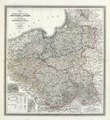 C.F. Weiland - Preussen und Posen, Polen 1855.pdf 12,018 × 13,129; 16.43 MB
-
.jpg/120px-Samogitia_(1855).jpg) Samogitia (1855).jpg 11,480 × 10,505; 26.75 MB
Samogitia (1855).jpg 11,480 × 10,505; 26.75 MB
-
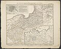 Die Preuss. Provinzen Preussen und Posen.jpg 5,547 × 4,495; 8.22 MB
-
 Grobiņas apriņķis 1859.jpg 641 × 1,593; 427 KB
-
 Этнографическая карта Европейской России.jpg 202 × 256; 23 KB

.jpg)

